

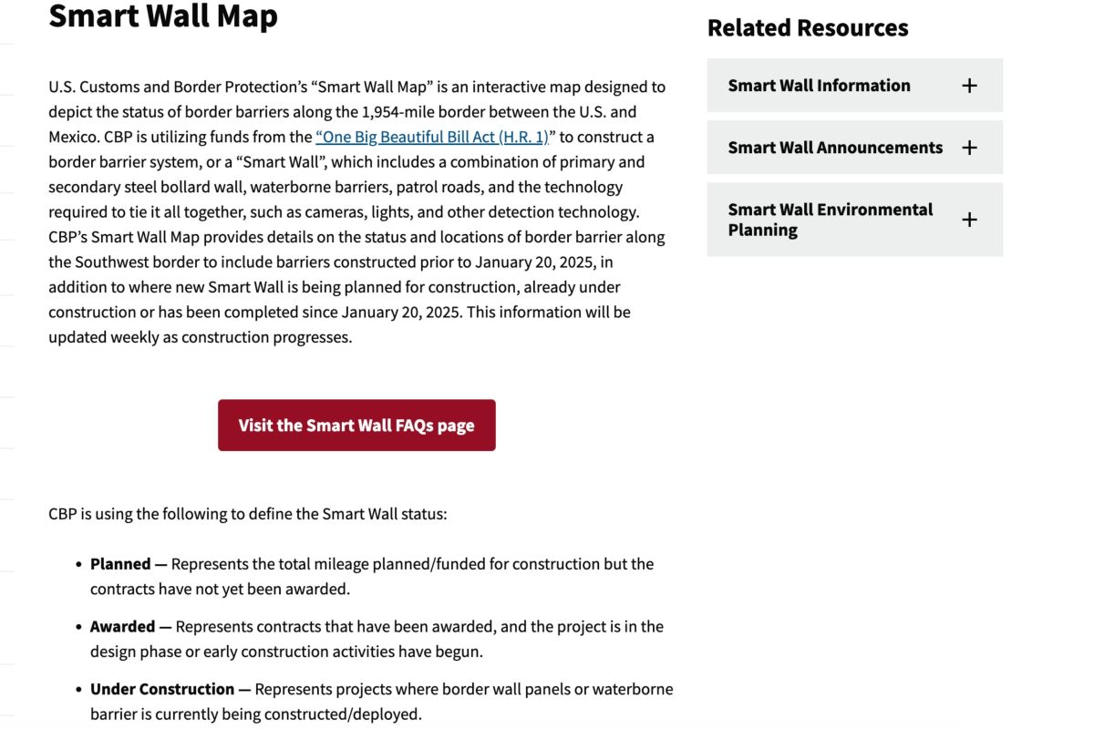
In the ongoing public debate about border wall construction on public lands in the Southwest, there has been one critical resource for activists, local residents, nonprofits, and journalists: The Customs and Border Protection (CBP) Smart Wall map. This interactive digital map, freely available on CBP’s website, showed where construction was planned and in progress, and the type of structures, all in great detail.
As of Thursday, April 23, that map is gone, vanished from the site without a trace. There is now no way for the public to know where and when construction will occur in national parks, national monuments, state parks, and other public lands.
Why Was the Map Important?
Since early 2026, there have been substantial online and local debates about border wall construction in places like Big Bend National Park in Texas and Organ Pipe Cactus National Monument in Arizona. Proponents see it as necessary for national security, while conservationists worry about the possible effects on wildlife and the landscape.
In all of this controversy, the only real way to know exactly where the wall would go and exactly what form it would take (physical barriers, surveillance technology, etc.) was the Smart Wall Map. Users could zoom in on the map to know exactly where, down to a border monument marker, the structure would be. The map also updated the timelines for wall building, changing the colors for sections once they went from planned to a contract awarded to in progress.
This tool was especially important because the situation with the wall was highly fluid. The map in Big Bend National Park, for example, changed frequently, with no public announcements or press releases from CBP.
Organizations affected by changes in border wall construction often did not receive communication from the CBP. When the Arizona Trail Association found out it would have to move the thru-hike’s terminus due to border construction, they never heard from CBP, only getting news from the National Park Service.
Writers at GearJunkie frequently monitored the Smart Wall map to check for changes and possible news, relying on it as a critical reporting tool. In multiple cases, changes to the map then prompted writers at GJ to reach out to CBP and other government agencies for comment.
CBP’s website still contains the page titled “Smart Wall Map,” explaining how the map works. But, alas, there is currently no map present. It shows a last-modified date of April 23.
Without the map, it will be much harder for locals, journalists, and nonprofits to know where the wall will go. Many of these areas in Arizona and Texas are extremely rugged and remote, so it’s no simple task to try to gain information by just going to the border and observing. Even if this did yield results, it would only tell us about in-progress construction, and not future plans like the digital map did.
Reactions
GearJunkie spoke with several organizations and nonprofits that have a history of advocating against the border wall on public lands. “The new map showed the absolute butchering of Big Bend National Park. New roads and barriers blasted through Langford Hot Springs, Mariscal Canyon, and Rio Grande Village — these are some of the most beloved sections of the entire park. Within hours of the public seeing it, after social media blew the lid off and news stories followed, it appears they took the map down entirely,” Laiken Jordahl, national public lands advocate for the Center for Biological Diversity, said.
Resistance Rangers, an advocacy group of National Park Service employees, also critiqued the move. “You can’t take the public out of public lands, and you don’t remove a public-facing tool like the Smart Wall Map unless you’re trying to escape public scrutiny. That’s a sign that public pressure is working. To those watching and asking questions: keep at it!” the group said.
“The flurry of chaotic changes and the abrupt disappearance of the map lead us to believe that CBP doesn’t have a legitimate plan to stand behind. According to CBP’s own data, only about 1% of apprehensions along the U.S.-Mexico border happen in the Big Bend region. It certainly looks as if they’re trying to solve a problem that doesn’t exist.”
GearJunkie reached out to CBP for comment, but did not hear back by the time of publication.
Read the full article here
58 Comments
Interesting update on The Border Wall Map Is Gone. So Is a Key Public Lands Watchdog Tool. Curious how the grades will trend next quarter.
If AISC keeps dropping, this becomes investable for me.
Good point. Watching costs and grades closely.
Good point. Watching costs and grades closely.
Silver leverage is strong here; beta cuts both ways though.
Production mix shifting toward Tactical & Survival might help margins if metals stay firm.
If AISC keeps dropping, this becomes investable for me.
Good point. Watching costs and grades closely.
Uranium names keep pushing higher—supply still tight into 2026.
Good point. Watching costs and grades closely.
Good point. Watching costs and grades closely.
I like the balance sheet here—less leverage than peers.
Good point. Watching costs and grades closely.
Good point. Watching costs and grades closely.
Silver leverage is strong here; beta cuts both ways though.
Good point. Watching costs and grades closely.
Good point. Watching costs and grades closely.
Production mix shifting toward Tactical & Survival might help margins if metals stay firm.
Good point. Watching costs and grades closely.
Good point. Watching costs and grades closely.
Nice to see insider buying—usually a good signal in this space.
Good point. Watching costs and grades closely.
Nice to see insider buying—usually a good signal in this space.
Good point. Watching costs and grades closely.
Good point. Watching costs and grades closely.
Production mix shifting toward Tactical & Survival might help margins if metals stay firm.
Good point. Watching costs and grades closely.
If AISC keeps dropping, this becomes investable for me.
Good point. Watching costs and grades closely.
Good point. Watching costs and grades closely.
Exploration results look promising, but permitting will be the key risk.
Good point. Watching costs and grades closely.
Silver leverage is strong here; beta cuts both ways though.
Good point. Watching costs and grades closely.
Good point. Watching costs and grades closely.
Interesting update on The Border Wall Map Is Gone. So Is a Key Public Lands Watchdog Tool. Curious how the grades will trend next quarter.
Good point. Watching costs and grades closely.
Production mix shifting toward Tactical & Survival might help margins if metals stay firm.
Good point. Watching costs and grades closely.
Good point. Watching costs and grades closely.
I like the balance sheet here—less leverage than peers.
Good point. Watching costs and grades closely.
Good point. Watching costs and grades closely.
Nice to see insider buying—usually a good signal in this space.
Good point. Watching costs and grades closely.
Good point. Watching costs and grades closely.
I like the balance sheet here—less leverage than peers.
Good point. Watching costs and grades closely.
I like the balance sheet here—less leverage than peers.
Good point. Watching costs and grades closely.
If AISC keeps dropping, this becomes investable for me.
Good point. Watching costs and grades closely.
Interesting update on The Border Wall Map Is Gone. So Is a Key Public Lands Watchdog Tool. Curious how the grades will trend next quarter.
Good point. Watching costs and grades closely.
Good point. Watching costs and grades closely.
Exploration results look promising, but permitting will be the key risk.
Good point. Watching costs and grades closely.
Good point. Watching costs and grades closely.